


How should we use WhatsApp to be rescued in case of emergency?
Luis Rincon, chief official of the GERA, explains in an article in the newspaper ABC how to use the application of WhatsApp messaging to be rescued in the mountain. As our sport also has risks, we have thought from TN that this information would be useful. Then we leave the full article.
El Rescue Group at Height (GERA) of the Region of Madrid has rescued more than 20 people - lost or injured - in the sierra thanks to the application of WhatsApp messaging. But how does this application really allow to reveal, precisely, where are the hikers? Luis Rincon, chief officer of the GERA, explains how a mountain rescue is carried out using WhatsApp.
Among the advantages offered by a smartphone compared to a conventional mobile device is that the former are mostly equipped with GPS system. "Many users are unaware that their phones have this tool that is very useful for us," he says.
Since they began to be used, the first thing that the GERA requests from a person lost in the mountain is that they activate it. "What was happening before we discovered that it is possible to send them on WhatsApp is that by dictating the Coordinates they committed mistakes due to cold or nerves», Explains Luis Rincón. "Three months ago, gathered before an emergency call, one of the team's firefighters said spontaneously:" send it to us on WhatsApp "and since then we have rescued eight groups of hikers in the sierra ».
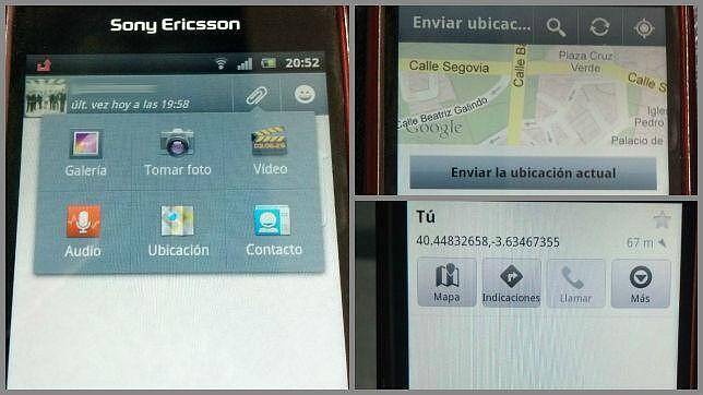
First step: Establish contact
After registering the call in the 112, the GERA starts up and "whenever there is 3G coverage, we ask the aid claimant to take note of the mobile number of one of the members of the unit and add us to their contact list. to be able to start a conversation on WhatsApp », he explains. "If there is no coverage, you have to try to find it but avoid taking too many risks."
Second step: Activate your GPS
«Once the contact is established, we ask you to activate the GPS of the phone that will allow geolocalize the hiker with a margin of error of plus or minus ten meters. Before, when we took note of the coordinates there was a margin of error of five kilometers. It has been shown to be safer than dictating the figures from an altimeter or a Mountain GPS and, of course, easier and faster, "says the chief officer of the GERA.
Third step: Send your location
«The third and last step before deploy the rescue team is that they send us their location. The application of WhatsApp allows, through the "clip" of attach file, send the location. Once sent, in a few seconds, we receive the exact coordinate of your position. We ask you to wait for us in the same place from where you sent us the message and proceed to deploy our team. In the last three months it has been a success»
Source: .abc.es
There are no previous results.